Fun part begins when you discover than a trail shown on the map does not exist. Or, in many occasions, is clearly indicated by a locked gate. After some search in the bushes along highway S-2, we decided to go for more reliable paved road that turns off Highway 79 near Warner Springs Ranch. The road snaked along the hills, and lead us to the Los Coyotes Indian Reservation. Here you pay $10 at the gate, and I'd say it was the best-spent tenner during my life in San Diego!
First, the road surface turns into a good graded dirt. In a few miles,
you come to a very nice and spacious campground (how about an acre
per site? just a **little** hyperbola). The road continues into the
woods - fir, pine, oak, etc., not too much overgrown and thick. Plenty
of hiking trails, would take forever to explore. And, finally, plenty of
Jeep trails, MOST of them topping Coyote Canyon bypass that we took. In
future, I plan to add a trail map of this park, and show my very modest
advances.
![]()
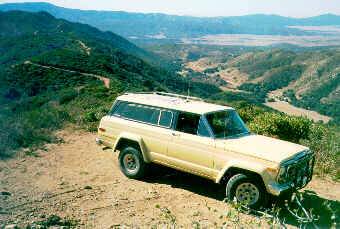 |
We began our trail exploration with some dirt road that winds up to
Marshmallow Hill - very easy, just a bit steep, and off-camber sometimes
- and up to ~5500 ft. You can see Anza-Borrego, Lake Henshaw, and probably
Salton Sea (in a very clear day) from the same point!
One bit of excitement - to make a U-turn on that spot that is barely a few feet larger than the truck's length, with looooong drop-offs on all sides. The trail proceeds along the ridge (can bee seen on the picture) to yet another peak - didn't go there. You don't need 4wd for that side trip, but rare rigs come with 2-lo (which is desirable). |
| After descending to the main road, we started looking for some four-wheeling excitement. It didn't take too long; first trail off to the East proved to offer more that I would like to take with only a come-along for a getchaback service. Later, we identified this trail as Old Mine Road. It starts quite easy and relaxed, and as you go in, it becomes narrower, twistier, steeper, etc. One side excursion discovered someone's past sand hill climb attempt. I only managed to make a few yards up this slope; the terrain doesn't let you to gain any momentum to get going. One of the few occasions when I had all four tires spinning, and just single - without any progress! Put it off 'til I get 33+" mudders. | 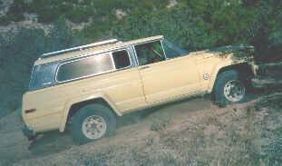 |
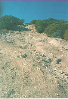 |
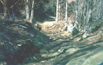
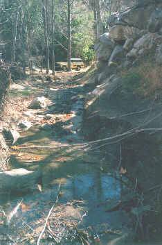
The trail started getting nastier. Don't know if the picture on the left gives any impression of smoothness of the surface, let's just say it is a bit bouncy. Now it indicated clear tendency to go down the canyon, along the creek. The count of water crossings was soon lost; the trail is obviously easier for short-wheelbase rigs with short overhangs. Once I hit the ground with my front bumper approaching the creek! Now and then some rocks appeared, growing in size and being laid out in denser and rougher pattern. Still, my 2" lift blocks in the rear paid off well, scored just a few hard hitch receiver hits. Off-camber situations became also more frequent, none dangerous for a simple reason - virtually nowhere to roll, with nearby trees' bark bearing scratches from previous exporers. If your paint job is vauable for you, better hike down this road. The branches threatening it come in 1"-2" thick variety. Dead tree trunks enhance the creek crossings with a foot-sized rocks and sandy bottom. |
 |
 |
| I didn't go to the end of any trail, for the reason of 50% chance of
breakage or getting badly stuck, and only having my brother and 3-ton come-along
to get me out. The picture on the right witnesses my shameful stop and
turnaround. I could have made this portion of the trail without much wrestling
and (probably) not much damage, but on this trail challenges proved to
go one way. Behind the scene there is an abandoned Toyota pickup truck;
wonder how the guys made it that far. It could've only been winched from
there.
Now, about the trail features. See these two trees left from my truck? Funny thing is that my jeep wouldn't make it along the seemingly obvious way, right of those two trees, and the path left of the trees should be chosen. I would've been wedged tight between a 2.5-ft rock and the tree; in a while three CJs "blasted" by at one place, at a fraction of a mile per hour, one - almost got stuck being barely able to yank his tires from that vise grip. In most tight places along this and other trails the line for a full-size Jeep must be chosen with very little respect to what the tracks indicate! This road was said to lead to an old mine; being a bit short in time and eager to check other places, we left the trail 'til the next time. Pete Griffith, I need you there! |
 |
Here I returned to my beast, parked in a weird position near the bottom
of that boulder. A - what - 11-point turn was employed to get the rig around,
and up I went. The need of a front locker became strikingly obvious right
away. I made it up on the third or fourth attempt, choosing a different
line every time and gunning the engine.
At this point, it was almost 3 p.m.; at 4 p.m., the park authorities
would charge me aditional ten bucks, and in such deep canyons it would've
become dark, so we cut our trip short and headed home.
Among the unexplored, there was a trail called "Dangerous Road", while
others being up to a built short-wheelbase rig with at least 33-inchers
around and a locker or two didn't receive such title!
Too bad photo shop botched the negatives, so all the pics are sort of
faded. But, when you get there you won't believe it, so beautiful the place
is. It's not the desert in any way, totally different. Doesn't change my
attitude towards Anza Borrego, but as for the family weekend fun, it definitely
tops the desert.
![]()
Note the previous photo. That's pretty much where the next story begins,
of our trip with Pete Griffith past that place
- follow the link:
Los Coyotes Indian Reservation
- Trip of Jan.30, 1999
![]()